Bureau predicts scorching summer ahead

Lucy Dedman
22 October 2024, 8:20 PM
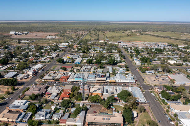 Towns like Bourke could expect higher temperatures this summer
 Australia is bracing for one of its hottest summers on record according to the Bureau of Meteorology’s (BOM) seasonal weather modelling, which predicts well-above-average temperatures across much of the country.
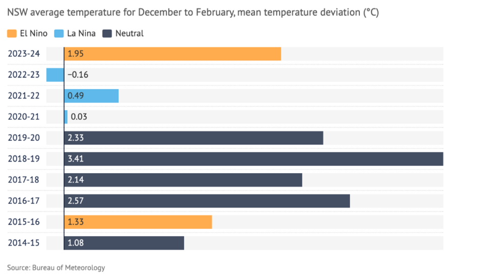
The temperatures are expected to sit at about 1.5C above the baseline 1961-1990 average, which would position the upcoming summer in the top five hottest on record.
As the mercury begins to lift a little this week, western plains communities might need to think a little harder when planning their summer coping strategies.
The weather bureau predicts that the climate from November to February is anticipated to be both wetter and warmer than average. Overnight minimum temperatures are also expected to exceed previous averages during this period.
The forecast for intense heat is largely attributed to persistently high ocean temperatures in the Eastern Pacific.
The Department of Primary Industries Climate Applications Research Officer, Dr Jennifer Wurtzel said ‘it's those above average ocean temperatures that are pretty much around all of Australia that is likely contributing to why we have this warmer than average climate forecast for the next few months.’
A sweltering summer amplifies the severity of extreme hot days and the risk of bushfires. District Manager of the Northwest Rural Fire Service (RFS) Zone, Inspector Luke Robinson said the bushfire season for the region ‘would be an above average chance of a late fire season due to the grass growth and the weather patterns that we're seeing.’
Summer heat
‘The forecasted summer of extremes comes with a short burst of above average temperatures for greater than three days, in which our crews in the RFS will have to make sure that we're ready for and able to respond to those.’
In preparation, Inspector Robinson said ‘at a district level, we've been engaging with our brigades, our senior volunteers, running exercises with the fire control centre and updating all of our preplanning.’
With the push to get more modern firefighting vehicles into regional areas, the Northwest Zone received ‘mobile data terminals’ for every truck and vehicle in the district which ‘help give our volunteers more information quickly without the hurdles of utilising a radio in the field.’
‘We've also had the investment and soon to arrive, capability of a large bulk water tanker, about 16, 000 litres of water on board and there's only five being delivered around the state which will be a big capability boost.’
The Bureau of Meteorology's National Community Information Manager, Andrea Pearce said ‘The Bureau works closely with fire authorities to monitor weather conditions, issue fire danger ratings and warnings to keep the community informed’.
Despite the hot temperatures, the Bureau predicts average rainfall which lowers the risk of bushfires. Dr Wurtzel reiterates that ‘we're having these persistent warm temperatures off Australia putting all this moisture and energy into the atmosphere.
As part of the reason La Nina tends to bring rain, ‘a couple of models are showing a La Nina forming, but if it does form, it's expected to be weak and probably short lived.’
Summer rain
Summer rain
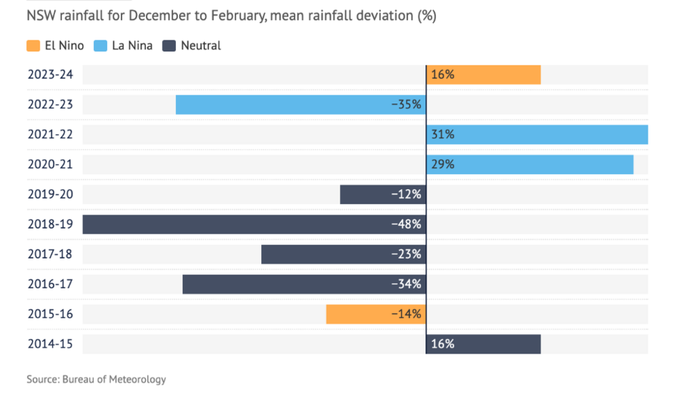
The increase in humidity is likely to mean more summer thunderstorms, comparable to the storms experienced throughout Western NSW last week. ‘There's still a lot of variability, we tend to have more of those rain bands come across that bring a lot of those summer storms that are hit or miss, very patchy, across the state,’ Dr Wurtzel said.
While weather forecasting is inherently not about certainty but probability, national figures show that seven of the past 10 summers have been hot and wet, and three have been hot and dry.
All 10 summers were hotter than the 1961–1990 national average, a sign of how the climate has changed over the past three decades.
‘Last year an El Nino was predicted, and it absolutely occurred, but the impacts of those climate drivers on Australian climate on rainfall are what has been a bit out of the ordinary.’